Hong Kong Construction Contractor Catches Excavation Deviations, Cuts Rework by 60% with viLid by viAct
A leading Hong Kong contractor managing a large-scale mixed-use project faced mounting pressure from undetected excavation deviations, costly reworks, and tightening DEVB BIM compliance requirements. Traditional site surveys were too infrequent to catch deviations before follow-on trades began. By deploying viAct viLid 4D LiDAR Reality Capture System, the team transformed site monitoring into continuous spatial intelligence, stopping rework before it started.


60% Reduction in Rework
through the real-time Excavation deviation detection before follow-on trades begin

3200+ Hours Saved
by replacing manual topographic surveys with continuous LiDAR scanning

100% Audit-Ready
as-built BIM traceability in full compliance with DEVB TC(W) No. 1/2025
Company Overview
This Hong Kong-based contractor is one of SAR's established construction contractors, with an active portfolio spanning residential towers, commercial complexes, and government infrastructure. Employing 3,500+ personnels, the firm operates across the full scope of HK's Construction 2.0 requirements. As a government capital works contractor, DEVB's progressive digital requirements directly shape every project the company delivers.
Story Snapshot
Burdened by infrequent manual surveys, growing deviations between BIM models and site reality, and an urgent DEVB compliance deadline, the contractor turned to viAct’s viLid. Combining fixed-point LiDAR poles and drone scanning, the team achieved real-time 4D site intelligence, cutting costly reworks, saving survey hours, and delivering a fully audit-ready as-built record.
Industry:
Construction
Location:
Hong Kong SAR
Use Case:
viLid
The Challenge
Catching Excavation Deviations Before Follow-On Trades Make Rework Inevitable
The contractor was delivering a large mixed-use development involving deep basement excavation within a dense urban corridor, where adjoining structures and live underground infrastructure demanded precise lateral support works throughout. Site monitoring relied on manual topographic surveys every 4-6 weeks. By the time deviation reports reached engineers, formwork was stripped and follow-on trades had started. Correcting misalignment meant demolishing completed work and absorbing programme delays that cascaded across the entire sequence.
The firm's BIM model that updated quarterly from manual surveys, was increasingly diverging from site reality, creating legal and financial consequences, the team could no longer defer. They needed a system that closed the loop between the digital model and the physical site continuously.
“viLid changed the way we read our own site. What used to take six weeks to surface, now flags before the next shift begins. All thanks to viAct.”

Project Director
Hong Kong Construction Contractor
The Solution
Multi-Mode viLid Deployment for Continuous Spatial Site Intelligence
To close the gap between BIM model and site reality, the contractor deployed viLid in all three scanning modes: fixed-point LiDAR poles, drone-based LiDAR, and handheld scanners. The system generated high-density coloured point clouds continuously, comparing as-built conditions against BIM model in near real-time. Deviations beyond defined tolerance thresholds were flagged automatically, colour-coded in the 3D viewer, and linked directly to the relevant BIM element, enabling correction before downstream trades began.
"When viLid flagged a 7 cm wall deviation on Tuesday morning, formwork was still in place. Our team corrected it by Wednesday afternoon. Under our old system, we would have found it six weeks later, after tiling," said the Site General Manager.
"viAct’s dashboard gave us something we never had before: a live view of exactly where the site stood against our BIM model, at any moment. The first deviation it caught saved us more than the entire deployment cost. The system paid for itself immediately," added the Commercial Director.
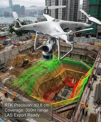
Fixed-Point LiDAR Poles for Continuous Excavation and Deformation Monitoring
Fixed-point LiDAR poles deployed across the excavation perimeter operated continuously at 240,000 points per second with ±2 cm accuracy, generating time-stamped 4D models of ground deformation, excavation face conditions, and lateral support wall movement, delivering spatial coverage and precision that no periodic manual inspection schedule could replicate.
When AI analytics flagged threshold movement at an earth retaining wall section, engineers were notified before the next shift began; zero rework, zero programme delay. Under the previous inspection cycle, the same deviation would only have surfaced after significant further deformation had already accumulated.

Drone-Based LiDAR for Progress Validation, BIM Alignment, and DEVB Audit Readiness
Weekly drone scans generated aerial 3D models compared against the BIM model, with exports feeding the project's Common Data Environment for continuous audit-ready as-built records. When the Buildings Department inspected in Month 7, the team presented a complete 18-week 4D construction history, meeting TC(W) No. 1/2025 expectations fully.
“With viLid, BIM compliance has become far smoother. What used to mean weeks of manual survey reconciliation is now a continuous, audit-ready digital record. It helped us prove as-built conditions in real time and avoid costly corrections downstream,” said the BIM Manager.

The Impact
Building Compliance Resilience and Competitive Advantage with viLid
Beyond rework reduction, viLid created a living spatial record, a trusted data trail supporting DEVB audits, tender submissions, and insurance negotiations where continuous as-built verification is now a scored differentiator in capital works procurement.
The 4D monitoring framework viLid established is now being replicated across the contractor's upcoming projects, proving scalability beyond a single deployment.
viLid replaced periodic manual reports with live spatial data, shifting every team from reactive corrections to precise, proactive decision-making throughout the project.
"With viLID, our BIM model and site reality finally moved together, in real time," said the Project Director.
Project Manager
Hong Kong Construction Contractor